
Sharon’s Hiking Trails
See the town map below for established hiking trails in Sharon. Click on colored areas for more information about an area. Click on trail labels to see some videos of hikes. Read about the progress that SFOC is making in mapping Sharon’s trails.
Now available: Detailed 11″ x 17″ color trail maps, with notes, photos and commentary for Sharon’s Massapoag, King Philip’s Rock, Beaver Brook and Horizons for Youth conservation areas. These maps are far more detailed than as shown on our website and are printed on a tough, completely waterproof paper. We are asking $4.00 each ($3.50 for members) for these maps which equals our printing and mailing costs. You may join SFOC for $25/year (includes family) and receive the member price at the same time.
Please contact:
Kurt Buermann
45 Furnace St.
Sharon, MA 02067
Also available: List of picnic table locations in Sharon (see latest list).
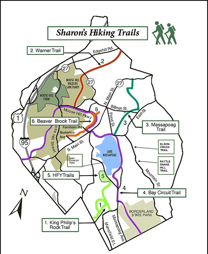
1. King Philip’s Rock Trail
Mansfield Street to King Philip’s Rock and beyond. Map available.
2. Warner Trail
Begins at the Sharon/Canton line and proceeds 30 miles south into Rhode Island.
3. Massapoag Trail
Lake Massapoag to North Main Street (Rte. 27). Map available.
4. Bay Circuit Trail
150 miles of trails connects 79 parcels of protected land to form a “greenway” around Boston. Maps available.
5. Horizons for Youth (HFY) Trails
56 acres of land off Lakeview Street that had been the property of a summer camp and is now home of several hiking trails. Map available.
6. Beaver Brook Trail
Almost 2 miles long running from the end of Berkshire Ave to the Sharon train station (near the Tennis club). Map available.
The Elson-Cross trail at 276 Mountain St. is a .85 mile loop with interesting rock features and a hemlock swamp. Request map: sharonfoc@gmail.com
The Lakeview Lookout trail is a short 1/10 mile path which brings you to a secluded opening on Lake Massapoag. Relax on a bench there
The trail entrance is marked by a sign and is .16 mile from Livingston Dr on Lakeview St. or .60 mile from the Morse St. intersection. Request map: sharonfoc@gmail.com
The Rattlesnake Hill trail leads to the summit of Rattlesnake Hill. The entrance is about 339 Mountain St. Request map: sharonfoc@gmail.com
Moose Hill Wildlife Sanctuary
The Mass Audubon Society’s oldest sanctuary has more than a dozen trails traversing its nearly 2,000 acres of forest, grassland, swamp, and bogs.
Moose Hill Farm
Two miles of trails lead to summit fields, where grassland birds are again finding a home.
Borderland State Park
Set on the grounds of the Ames Mansion, more than a dozen trails offer hiking, horseback riding and skiing.