| |
Letters to the Editor: Swamp Story
These letters refer to a story about Sharon's
Atlantic White Cedar Swamp which ran in SFOC's Spring
2006 newsletter. An Editor's Note responding
to these letters has since been published.
May 9, 2006
To the Editor:
I was certainly shocked to open up the Spring
2006 Newsletter and see the photo of standing dead cedar
trees in an area of the cedar swamp across from my home on East
Foxboro Street along with an article written by Kurt Buermann and
Clifford
Towner. This photo was captioned, “Dead cedar trees are just
one sign of the critical condition of Sharon’s Atlantic White
Cedar Swamp” and illustrated a story that says, “These
cedars are dead and dying because the water table has been lowered
by human activities such as ditching and pumping of municipal wells.” This
gives the impression that the trees shown in the photo died because
of the swamp’s drying out. This is not so.
I moved into my home in 1979, and every year I witnessed the water
level grow higher and higher at this site. The trees slowly began
to die. During the 1980s I would sit on my porch and watch the trees
fall down and the ever-higher levels of standing water become putrid.
I began an effort to try to get the Town to do something to restore
this area. I did not get much support and was put off by people’s
telling me that dead cedars were good for nesting birds. It was
not until 1993 that I organized the neighbors in this area to get
a hearing
before Conservation Commission to restore the swamp by lowering
the water level. The older neighbors said that changes on this
site began
when two houses were constructed that blocked the drain from the
swamp to the lake, with the water trapped within the swamp, and
the wetlands across the street and nearest the lake drying up.
There was vocal opposition to this requested restoration even though
more and more trees were dying in the high water. No one spoke
up at that time about the importance of the cedar swamp or the
living
cedar trees. I was told that since the trees were almost all dead,
there was no point in restoring this site. A wildlife habitat assessment
by Fugro-McClelland (East) Inc., commissioned in 1993 by the Conservation
Office, states, “FM-East agrees with the opinions expressed
by Bruce Sorrie relative to the proposal to restore the red maple–Atlantic
white cedar swamp” and cites Motzkin (1991): “Increased
water levels caused by human interference with normal drainage
patterns appears to be the single factor most frequently responsible
for recent
site degradation.”
The Town proceeded with an engineering project in 1993 or 1994 that
allowed the water to return to its natural flow pattern. The printed
photo shows this area with the new growth that, according to Greg
Meister, Conservation Agent, includes young cedars mixed with red
maple trees. In the background you can still see standing the trees
that began to die during the period of increased water. It causes
me much dismay to see this photo of the cedar swamp off East Foxboro
Street printed and used as an example of damage due to decreased
water.
Katherine Byrne
May 15, 2006
To the Editor:
I have read the e-mails from Alice Cheyer and Kathy Byrne with regard
to my article on the Cedar Swamp. … I am responding only because
you and the board of SFOC trusted me to write an article about the
White Cedar Swamp for your publication.
First, let’s look at the photograph with the [printed
newsletter] article, which I had nothing to do
with. That photo is not of the Cedar Swamp nor has that area been
part of the Cedar Swamp for generations. All of the dead trees in
the photo are white pine, not cedar. Anyone with any knowledge of
trees knows that pines do not grow in flooded wet swamps, and anyone
who looks at the photo can tell those pines were growing for many
years. Those pines were killed by high water along with all the hardwood
trees that were harvested in the mid-nineties. Hardwood trees twelve
to fifteen inches in diameter also do not grow in flooded cedar swamps.
That area along East Foxboro Street flooded in the mid-eighties because
of plugged drainage pipes and a lake level that was raised a foot
higher than it is carried today. The area in the photograph was isolated
from the main cedar swamp by the railroad tracks in the 1800s, and
the area along East Foxboro Street was further isolated by a railroad
spur to haul ice out of the lake.
I wrote about Sharon’s White Cedar Swamp, not [the area along
East Foxboro Street]. …
Sharon has a serious groundwater problem; the cedar swamp is the
linchpin supporting our drinking water; pull that pin and we are
on MWRA. [The Massachusetts Water Resources Authority brings water
from Quabbin and Wachusett reservoirs, west of Boston, to local water
departments in 48 communities—Editor’s note].
I congratulate the Sharon Friends of Conservation for addressing
this very important environmental issue. The article in your newsletter
about the cedar swamp is absolutely correct in every respect.
Cliff Towner
June 4, 2006
To the Editor:
 As
an SFOC board member who takes part in publishing the newsletter,
I was upset when Ms. Byrne wrote that the photo illustrating the
White Cedar Swamp story printed in the spring
newsletter did not in fact show what the caption and article implied:
that cedars had
died as a result of the drying out of the cedar swamp. It turns out
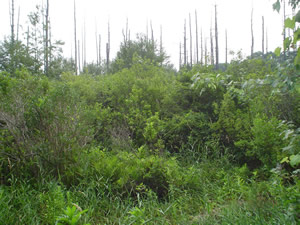
she is correct: (1) both the autumn photo in the newsletter and
the summer photo posted on the Web site [shown at left] for a month
(until replaced) were judged by the ecologists Glenn Motzkin at Harvard
Forest and Tim Simmons of NHESP to show white pines, not cedars;
the newsletter accepts responsibility for erroneously captioning
and implying that these were cedars, and inadvertently misleading
its readers. (2) The 1993 wildlife habitat assessment mentioned in
Ms. Byrne’s letter states that the 14-acre wetland off East
Foxboro Street “contained red maple saplings and occasional
specimens of Atlantic white cedar … and increased water levels
caused by human interference with normal drainage patterns appear
to be the single factor … responsible for recent site degradation” [my
italics]. Note that any abrupt change in water levels (high or low)
can disrupt cedar swamps[1] as well as other tree habitat. As
an SFOC board member who takes part in publishing the newsletter,
I was upset when Ms. Byrne wrote that the photo illustrating the
White Cedar Swamp story printed in the spring
newsletter did not in fact show what the caption and article implied:
that cedars had
died as a result of the drying out of the cedar swamp. It turns out
she is correct: (1) both the autumn photo in the newsletter and
the summer photo posted on the Web site [shown at left] for a month
(until replaced) were judged by the ecologists Glenn Motzkin at Harvard
Forest and Tim Simmons of NHESP to show white pines, not cedars;
the newsletter accepts responsibility for erroneously captioning
and implying that these were cedars, and inadvertently misleading
its readers. (2) The 1993 wildlife habitat assessment mentioned in
Ms. Byrne’s letter states that the 14-acre wetland off East
Foxboro Street “contained red maple saplings and occasional
specimens of Atlantic white cedar … and increased water levels
caused by human interference with normal drainage patterns appear
to be the single factor … responsible for recent site degradation” [my
italics]. Note that any abrupt change in water levels (high or low)
can disrupt cedar swamps[1] as well as other tree habitat.
Mr. Towner, a co-author of the article, now states that the cedar
swamp area comprises two portions (west and east), separated by railroad
tracks, whose water levels function separately; that the east portion,
abutting East Foxboro Street, has not “been part of the cedar
swamp for generations”; and that he “wrote about Sharon’s
White Cedar Swamp, not [the area along East Foxboro Street].” The
isolation of the east portion by railroad tracks is confirmed by
the 1993 wildlife habitat assessment, but that report envisioned
that draining accumulated high water and managing water levels via
a culvert and flashboards “will … contribute to the gradual
restoration of a mixed forest canopy of red maple and Atlantic white
cedar.” According to Ms. Byrne, the restoration she sought
has in fact resulted in new growth off East Foxboro Street, including “young
cedars mixed with red maple trees.” So, it is possible that
both portions (west and east) were at one time, and may again become,
part of a mixed-stand cedar forest.
However, this relevant detail—a distinction between separate east
and west areas of the cedar swamp—was not made in the article presented
to the newsletter for publication, which merely described the White
Cedar Swamp as lying “west of Lake Massapoag.” Consequently,
the map inserted by the editor to illustrate the swamp’s
location took no note of such
a distinction. Mr. Towner now states that the east portion was “flooded
in the mid-eighties because of plugged drainage pipes,” which
agrees with the descriptions in Ms. Byrne’s letter.
The point is that all this confusion was occasioned by an article
that did not meet good journalistic standards, and the SFOC newsletter
should not have published it as is. Before publication, I argued
that at most it be published as an opinion column, not as a straight
news article.
Whether the article’s thesis is correct, I can’t say.
I do know that the errors and omissions attending its publication
undermine the credibility of the SFOC and its newsletter, and do
not keep faith with our goal of informing readers objectively about
conservation. I was not satisfied with the article because it did
not give much actual information on past activities (e.g., draining
or flooding by whom, when, why) nor scientific evaluations of the
swamp’s present vegetation and viability, its need for restoration,
and what such restoration would entail.
In 1999 the Conservation Commission nominated the “250-acre
cedar swamp” for restoration under the WRBP (Wetland Restoration
and Banking Program) in the state’s Executive Office of Environmental
Affairs, which provided technical assistance and help securing funding.
A WRBP team, including a white cedar specialist from Yale University,
completed a preliminary site assessment. A sum of $50,000 was being
sought for a fuller evaluation and a draft wetland restoration plan
(implementation costs to restore a white cedar swamp were said to
run up to $500,000).[2] “The project was not pursued by our
program,” wrote a WRBP manager recently, “primarily because
of uncertainty regarding a proposed municipal well and potential
effects on the site’s hydrology.”
Statements like These cedars are dead and dying because the water
table has been lowered by human activities such as ditching and pumping
of municipal wells sound logical, given growing population and increased
development, but in this article they were unexplained.
“Ditching” refers to a drainage ditch that was dug after
Heights houses were built in 1950, in order to prevent wet basements
and
failing septic tanks. Norfolk County also maintains ditches in Sharon
for mosquito control (cedar swamps are habitat for the mosquitoes
that spread the Eastern equine encephalitis virus through bird populations)[3].
As to “pumping,” for years there has been a debate between
factions in local government over well siting and water use in Sharon,
and how to balance a sufficient water supply for human use and the
conservation of water resources. Six years ago there was intense
disagreement over whether a new well could be sited on Chase Drive
near the cedar swamp without affecting it by pumping; that debate
is ongoing.[4] I do not think SFOC should involve itself uncritically
on any side of that debate.
Alice Cheyer
Footnotes
1. Throughout the northeast, only a fraction of earlier [cedar] stands
remain. . . . Cedar forests may be composed exclusively of an even-aged
cedar stand of close-ranked trees, or of uneven-aged mixed stands.
In mixed stands, the most frequently encountered trees are red maple
and black gum. . . . Mature white cedars are adapted to a wide range
of water depths. However, rapid, prolonged change in water depth
stresses or kills mature trees, and kills seedlings outright. . .
. An abrupt change in any of these regimes (e.g., flooding a dry
site, or drying a flooded site) is, by itself, a stress factor which
may negatively impact the community. Human activities in upland areas
immediately adjacent to cedar bogs also adversely affect white cedars.
. . . Land-use changes in upland areas can impact water table height,
water flow rates, and stream flooding characteristics -- factors
that are critical to the structure and function of cedar swamps.
--New Hampshire Coastal Program fact sheet, http://www.des.state.nh.us/factsheets/cp/cp-20.html
2. Neponset River Watershed Wetlands Restoration Plan, February 2000.
3. http://www.town.sudbury.ma.us/services/health/emmcp/infoareanew.htm
4. See www.townofsharon.net, Water Management Advisory Committee,
meeting minutes, January 19, 2006, and April 6, 2006.
Excerpt from e-mails, April 11 and 12, 2006, Conservation Commission and DPW
Superintendent, regarding new well sites:
ConCom: We strongly support
the DPW’s
efforts regarding the NSTAR site exploration and . . . potential sites along
Edge Hill Road. . . . With regard to further consideration of well sites within
the Great Cedar Swamp resource area, however, . . . we have serious concerns.
. . . The Commission strongly opposes any further effort aimed at developing
this very sensitive site within or adjacent to [the cedar swamp].
DPW Superintendent: While
the Commission has certainly stated on numerous occasions their concerns regarding
source exploration at the Chase Drive site, the Commission has never
brought forward the record of data. . . . Please understand that the Water Department
is proposing to perform pump tests at the site to directly measure impacts at
the proposed withdrawal rate.
Back to Items of Interest
|
|
