Bay Circuit Trail
 The
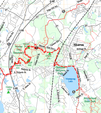
Bay Circuit Trail is 150 miles of trails connects 79 parcels
of protected land to form a "greenway" around
Boston.
The
Bay Circuit Trail is 150 miles of trails connects 79 parcels
of protected land to form a "greenway" around
Boston.
As described by the Bay Circuit Alliance:
First proposed in 1929 as an outer "emerald necklace," linking parks, open spaces and waterways from Plum Island to Kingston Bay, the Bay Circuit idea — a precursor of today's national greenways movement — continues to take shape. Focused on a 200 mile corridor of 50 cities and towns, the Bay Circuit Trail connects the "jewels" of the "emerald necklace." Community by community, the dream of connecting more than 79 areas of protected land in a greenway around Boston is now becoming a reality.
View the full detailed map of the Medfield to Sharon section of the Bay Circuit Trail. (596kb PDF)
Bay Circuit Trail Marking (Summer 2007)
Thanks to SFOC members Rita Corey, Brad Larson, Paula Sincero, and Mike Sherman, and Bay Circuit member Denny Nackoney, a resident of Wellesley, the first third of the Bay Circuit Trail as it runs through Sharon has been marked. The Bay Circuit Trail is a permanent recreation trail and greenway corridor extending through 21 towns in Eastern Massachusetts and linking the parks and open spaces surrounding metropolitan Boston. Thanks to Paula for making an excellent sign for the kiosk at Moose Hill that explains the marking symbols and tells about the trail. To help mark the remainder of the trail, call Rita Corey, 781/784-4533.
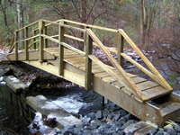 The
New Beaver Brook Footbridge (December
2007)
The
New Beaver Brook Footbridge (December
2007)
Sharon Friends of Conservation installed this 27 foot long footbridge December 8, 2007. Besides giving safer access to Sharon’s new Beaver Brook trail, it provides a link in the 200 mile-long “emerald necklace” Bay Circuit trail. For their help in building the bridge, SFOC wishes to thank the Sharon Conservation Commission, the Sharon Department of Public Works, Fields Pond Foundation (grant), the Bay Circuit Trail Alliance, Sharon’s Barney & Carey Lumber Co. (materials) as well as the dedicated team of SFOC members, Boy Scouts, and trail users who helped assemble the bridge at the site. Read more about the new Beaver Brook Footbridge…
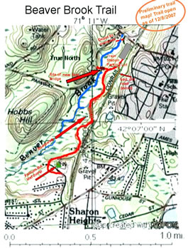
Beaver Brook Trail Map
The new Beaver Brook Trail runs from the west side (in-bound parking lot) of the Sharon train station to the Farnham Road dump area. (Click to view larger version)
Back to Sharon's Hiking Trails