
Endangered: Sharon’s Atlantic White Cedar Swamp
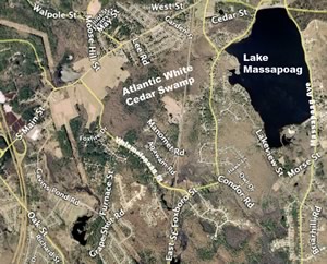 The Atlantic White Cedar Swamp west of Lake Massapoag lies atop Sharon’s largest and deepest aquifer. Over the millennia, decaying vegetation from the cedars has created a layer of peat up to six feet thick called Freetown muck, which is one of nature’s best water purifiers.
The white cedar swamp covers an area of over 600 acres. It accumulates and purifies rainwater, which then seeps into the underlying aquifer and flows out in all directions. It feeds the Canoe River, Beaver Brook and Billings Brook aquifers, as well as the springs that feed the lake. Sharon’s six municipal wells all trap water purified from the cedar swamp.
Due to its high elevation, no streams or brooks flow into Sharon, Sharon depends exclusively on rainwater. If the cedar swamp was completely covered over, and no rain was allowed to fall upon it, Beaver Brook and Billings Brook would become seasonal streams. The springs feeding Lake Massapoag would decrease and the lake would stagnate. Sharon would eventually run out of drinking water.
Atlantic white cedar trees require wetland conditions. Presently, there are hundreds of dead cedars in Sharon’s cedar swamp. These cedars are dead and dying because the water table has been lowered by human activities such as ditching and pumping of municipal wells. Sharon withdraws close to 600 million gallons per year from the ground, largely for residential use.
Airborne heavy metals such as mercury and other industrial pollutants accumulate in wetlands through rainfall and drainage. These pollutants are removed from the water by many species of wetland vegetation and the peat. This beneficial vegetation is being lost due to the drying out of our cedar swamp.
 Many species of upland trees and brush now occupy space where standing water once stood. Those species transpire water into the atmosphere much faster than Atlantic white cedars.
Once the peat (Freetown muck) dries out it will change state and no longer filter our drinking water.
Since 1997, Sharon has averaged over fifty-six inches of rainfall each year so you can see our loss of wetlands, streams, etc is not caused by a lack of rainfall.
This most valuable resource area could be protected and preserved simply by diverting the Sharon Heights storm drains into the cedar swamp, limiting further the hours of outdoor lawn watering and a very aggressive water conservation effort.
Fact: Each year Sharon loses more wetlands and less water goes into our drinking water aquifer.
Atlantic white cedar trees grow very, very slowly. Two hundred-year-old trees have been found measuring only a little over half a foot in height. These cedar trees can live as long as 300 years. If swamp water levels average lower, the result is an influx of invading trees and shrubs whose shade can easily stifle growth and regeneration of the light-loving cedars. Water levels are critical since the roots of the cedar trees themselves must be submerged for certain durations of time or the trees will die.
A “poster child” of an Atlantic white cedar swamp might well be the Hessel’s hairstreak butterfly. Cedar trees are the sole food source for the larvae of these rare, emerald-green butterflies. The cedar swamp is also an important breeding and living area for birds. These include: downy woodpeckers, brown creepers, magnolia warblers, black-throated blue warblers and ovenbirds. Water birds such as mergansers, wood ducks and green and great blue herons are often found in cedar swamps.
The fate of Sharon’s own Atlantic White Cedar swamp near Lake Massapoag is a looming crisis, not only in terms of jeopardizing a pure, toxin-free water supply for humans, but in preserving a unique habitat for wildlife as well. Plants and animals bound to the ecology of a cedar swamp are also direct indicators of the swamp’s health.
Perceived changes in the populations or biology of the cedar swamp ecosystem—such as the lamentable decline of spring peeper frogs in Sharon’s cedar swamp—are warning indicators of the swamp’s health. Some may minimize the importance of animal life in special ecosystems such as Sharon’s cedar swamp, especially the tiny creatures, but the animal life—especially the small organisms, directly affects plant life—the very plants which help to immobilize and filter out toxins which (mercury for example) otherwise would find their way into Sharon’s water supply.
Nature works in a circular way. Any disruptions of the water-animal-plant cycle may harm or even kill off the swamp. If the cedar swamp’s freely-given gift of purified drinking water is lost, we will lose a fascinating, intricate system of wildlife and plants, both rare and abundant.
Letters to the Editor regarding the story above:
May 9, 2006
To the Editor:
I was certainly shocked to open up the Spring 2006 Newsletter and see the photo of standing dead cedar trees in an area of the cedar swamp across from my home on East Foxboro Street along with an article written by Kurt Buermann and Clifford Towner. This photo was captioned, “Dead cedar trees are just one sign of the critical condition of Sharon’s Atlantic White Cedar Swamp” and illustrated a story that says, “These cedars are dead and dying because the water table has been lowered by human activities such as ditching and pumping of municipal wells.” This gives the impression that the trees shown in the photo died because of the swamp’s drying out. This is not so.
I moved into my home in 1979, and every year I witnessed the water level grow higher and higher at this site. The trees slowly began to die. During the 1980s I would sit on my porch and watch the trees fall down and the ever-higher levels of standing water become putrid.
I began an effort to try to get the Town to do something to restore this area. I did not get much support and was put off by people’s telling me that dead cedars were good for nesting birds. It was not until 1993 that I organized the neighbors in this area to get a hearing before Conservation Commission to restore the swamp by lowering the water level. The older neighbors said that changes on this site began when two houses were constructed that blocked the drain from the swamp to the lake, with the water trapped within the swamp, and the wetlands across the street and nearest the lake drying up.
There was vocal opposition to this requested restoration even though more and more trees were dying in the high water. No one spoke up at that time about the importance of the cedar swamp or the living cedar trees. I was told that since the trees were almost all dead, there was no point in restoring this site. A wildlife habitat assessment by Fugro-McClelland (East) Inc., commissioned in 1993 by the Conservation Office, states, “FM-East agrees with the opinions expressed by Bruce Sorrie relative to the proposal to restore the red maple–Atlantic white cedar swamp” and cites Motzkin (1991): “Increased water levels caused by human interference with normal drainage patterns appears to be the single factor most frequently responsible for recent site degradation.”
The Town proceeded with an engineering project in 1993 or 1994 that allowed the water to return to its natural flow pattern. The printed photo shows this area with the new growth that, according to Greg Meister, Conservation Agent, includes young cedars mixed with red maple trees. In the background you can still see standing the trees that began to die during the period of increased water. It causes me much dismay to see this photo of the cedar swamp off East Foxboro Street printed and used as an example of damage due to decreased water.
Katherine Byrne
May 15, 2006
To the Editor:
I have read the e-mails from Alice Cheyer and Kathy Byrne with regard to my article on the Cedar Swamp. … I am responding only because you and the board of SFOC trusted me to write an article about the White Cedar Swamp for your publication.
First, let’s look at the photograph with the [printed newsletter] article, which I had nothing to do with. That photo is not of the Cedar Swamp nor has that area been part of the Cedar Swamp for generations. All of the dead trees in the photo are white pine, not cedar. Anyone with any knowledge of trees knows that pines do not grow in flooded wet swamps, and anyone who looks at the photo can tell those pines were growing for many years. Those pines were killed by high water along with all the hardwood trees that were harvested in the mid-nineties. Hardwood trees twelve to fifteen inches in diameter also do not grow in flooded cedar swamps.
That area along East Foxboro Street flooded in the mid-eighties because of plugged drainage pipes and a lake level that was raised a foot higher than it is carried today. The area in the photograph was isolated from the main cedar swamp by the railroad tracks in the 1800s, and the area along East Foxboro Street was further isolated by a railroad spur to haul ice out of the lake.
I wrote about Sharon’s White Cedar Swamp, not [the area along East Foxboro Street]. …
Sharon has a serious groundwater problem; the cedar swamp is the linchpin supporting our drinking water; pull that pin and we are on MWRA. [The Massachusetts Water Resources Authority brings water from Quabbin and Wachusett reservoirs, west of Boston, to local water departments in 48 communities—Editor’s note].
I congratulate the Sharon Friends of Conservation for addressing this very important environmental issue. The article in your newsletter about the cedar swamp is absolutely correct in every respect.
Cliff Towner
June 4, 2006
To the Editor:
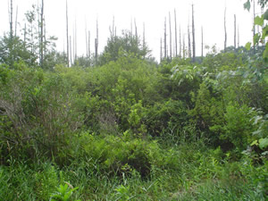 As an SFOC board member who takes part in publishing the newsletter, I was upset when Ms. Byrne wrote that the photo illustrating the White Cedar Swamp story printed in the spring newsletter did not in fact show what the caption and article implied: that cedars had died as a result of the drying out of the cedar swamp. It turns out she is correct: (1) both the autumn photo in the newsletter and the summer photo posted on the Web site [shown at left] for a month (until replaced) were judged by the ecologists Glenn Motzkin at Harvard Forest and Tim Simmons of NHESP to show white pines, not cedars; the newsletter accepts responsibility for erroneously captioning and implying that these were cedars, and inadvertently misleading its readers. (2) The 1993 wildlife habitat assessment mentioned in Ms. Byrne’s letter states that the 14-acre wetland off East Foxboro Street “contained red maple saplings and occasional specimens of Atlantic white cedar … and increased water levels caused by human interference with normal drainage patterns appear to be the single factor … responsible for recent site degradation” [my italics]. Note that any abrupt change in water levels (high or low) can disrupt cedar swamps[1] as well as other tree habitat.
Mr. Towner, a co-author of the article, now states that the cedar swamp area comprises two portions (west and east), separated by railroad tracks, whose water levels function separately; that the east portion, abutting East Foxboro Street, has not “been part of the cedar swamp for generations”; and that he “wrote about Sharon’s White Cedar Swamp, not [the area along East Foxboro Street].” The isolation of the east portion by railroad tracks is confirmed by the 1993 wildlife habitat assessment, but that report envisioned that draining accumulated high water and managing water levels via a culvert and flashboards “will … contribute to the gradual restoration of a mixed forest canopy of red maple and Atlantic white cedar.” According to Ms. Byrne, the restoration she sought has in fact resulted in new growth off East Foxboro Street, including “young cedars mixed with red maple trees.” So, it is possible that both portions (west and east) were at one time, and may again become, part of a mixed-stand cedar forest.
However, this relevant detail—a distinction between separate east and west areas of the cedar swamp—was not made in the article presented to the newsletter for publication, which merely described the White Cedar Swamp as lying “west of Lake Massapoag.” Consequently, the map inserted by the editor to illustrate the swamp’s location took no note of such a distinction. Mr. Towner now states that the east portion was “flooded in the mid-eighties because of plugged drainage pipes,” which agrees with the descriptions in Ms. Byrne’s letter.
The point is that all this confusion was occasioned by an article that did not meet good journalistic standards, and the SFOC newsletter should not have published it as is. Before publication, I argued that at most it be published as an opinion column, not as a straight news article.
Whether the article’s thesis is correct, I can’t say. I do know that the errors and omissions attending its publication undermine the credibility of the SFOC and its newsletter, and do not keep faith with our goal of informing readers objectively about conservation. I was not satisfied with the article because it did not give much actual information on past activities (e.g., draining or flooding by whom, when, why) nor scientific evaluations of the swamp’s present vegetation and viability, its need for restoration, and what such restoration would entail.
In 1999 the Conservation Commission nominated the “250-acre cedar swamp” for restoration under the WRBP (Wetland Restoration and Banking Program) in the state’s Executive Office of Environmental Affairs, which provided technical assistance and help securing funding. A WRBP team, including a white cedar specialist from Yale University, completed a preliminary site assessment. A sum of $50,000 was being sought for a fuller evaluation and a draft wetland restoration plan (implementation costs to restore a white cedar swamp were said to run up to $500,000).[2] “The project was not pursued by our program,” wrote a WRBP manager recently, “primarily because of uncertainty regarding a proposed municipal well and potential effects on the site’s hydrology.”
Statements like These cedars are dead and dying because the water table has been lowered by human activities such as ditching and pumping of municipal wells sound logical, given growing population and increased development, but in this article they were unexplained.
“Ditching” refers to a drainage ditch that was dug after Heights houses were built in 1950, in order to prevent wet basements and failing septic tanks. Norfolk County also maintains ditches in Sharon for mosquito control (cedar swamps are habitat for the mosquitoes that spread the Eastern equine encephalitis virus through bird populations)[3]. As to “pumping,” for years there has been a debate between factions in local government over well siting and water use in Sharon, and how to balance a sufficient water supply for human use and the conservation of water resources. Six years ago there was intense disagreement over whether a new well could be sited on Chase Drive near the cedar swamp without affecting it by pumping; that debate is ongoing.[4] I do not think SFOC should involve itself uncritically on any side of that debate.
Alice Cheyer
Footnotes
1. Throughout the northeast, only a fraction of earlier [cedar] stands remain. . . . Cedar forests may be composed exclusively of an even-aged cedar stand of close-ranked trees, or of uneven-aged mixed stands. In mixed stands, the most frequently encountered trees are red maple and black gum. . . . Mature white cedars are adapted to a wide range of water depths. However, rapid, prolonged change in water depth stresses or kills mature trees, and kills seedlings outright. . . . An abrupt change in any of these regimes (e.g., flooding a dry site, or drying a flooded site) is, by itself, a stress factor which may negatively impact the community. Human activities in upland areas immediately adjacent to cedar bogs also adversely affect white cedars. . . . Land-use changes in upland areas can impact water table height, water flow rates, and stream flooding characteristics — factors that are critical to the structure and function of cedar swamps. –New Hampshire Coastal Program fact sheet, http://www.des.state.nh.us/factsheets/cp/cp-20.html
2. Neponset River Watershed Wetlands Restoration Plan, February 2000.
3. http://www.town.sudbury.ma.us/services/health/emmcp/infoareanew.htm
4. See www.townofsharon.net, Water Management Advisory Committee, meeting minutes, January 19, 2006, and April 6, 2006.
Excerpt from e-mails, April 11 and 12, 2006, Conservation Commission and DPW Superintendent, regarding new well sites:
ConCom: We strongly support the DPW’s efforts regarding the NSTAR site exploration and . . . potential sites along Edge Hill Road. . . . With regard to further consideration of well sites within the Great Cedar Swamp resource area, however, . . . we have serious concerns. . . . The Commission strongly opposes any further effort aimed at developing this very sensitive site within or adjacent to [the cedar swamp].
DPW Superintendent: While the Commission has certainly stated on numerous occasions their concerns regarding source exploration at the Chase Drive site, the Commission has never brought forward the record of data. . . . Please understand that the Water Department is proposing to perform pump tests at the site to directly measure impacts at the proposed withdrawal rate.
Editor’s Note: Swamp Story
This Editor’s Note refers to a story about Sharon’s Atlantic White Cedar Swamp which ran in SFOC’s Spring 2006 newsletter. The story precipitated a number of Letters to the Editor to which the editor is responding in this note.
June 8, 2006
The picture in the print SFOC Newsletter to which Katherine Byrne objects was mistakenly taken of this area due to ease of access. The scene is easily visible from the roadside. The Newsletter apologizes for the confusion it may have caused. The picture has been removed from this website but is still viewable by downloading the PDF file of the SFOC Newsletter. Despite this photo error, the editor of the SFOC Newsletter stands solidly behind the article.
The area that Katherine Byrne’s and Alice Cheyer’s letters refer to—where the picture was taken—consists of approximately 14 separate acres by the northeastern corner of Sharon’s Atlantic white cedar swamp. This is a section where there has been excessive and prolonged flooding (years long) in this area due to its being isolated by railroad and street embankments on all sides, beginning over 100 years ago with one railroad embankment and later another embracing railroad spur to service Lake Massapoag’s ice industry. At different times these 14 acres were drained and at times flooded due to artificial, uncontrolled or intentional events. Hence, water level history within this area is not representative of the Cedar swamp.
Some might read the article, and incorrectly conclude, as Katherine Byrne seems to, that swamp restoration would mean permanent high levels of standing water. Actually the ideal goal is to divert water into the swamp but with due control over water levels in order to mimic the natural periods of higher and lower water most conducive to cedar growth and regeneration. Water level control would also involve—as the article points out—a careful monitoring of human-use water pumped from the swamp-fed aquifer. Tim Simmons of Massachusetts Natural Heritage & Endangered Species Program writes:
“Some [towns in Massachusetts] are pumping thousands of gallons per year with no detectable change [in swamp water tables] while a wetland on Long Island was completely dried up and replaced by upland vegetation as a result of excessive pumping.”
Restoration of Sharon’s cedar swamp would not involve flooding it. It would mean raising the water table to near the ground level, the swamp floor (This is the ground in the hollows and not over the mounds.) For short periods, higher water might be allowed in order to mimic nature wherein temporary higher water levels inhibit and prevent propagation of detrimental species which compete with Atlantic white cedars. A study[1] by the Massachusetts Water Resource Commission regarding a cedar swamp in Foxborough states:
“A threshold water table elevation of 154.00 feet NGVD[2] is required for the peat layer. This level is intended to keep water within one foot of the wetland hollow surface, as indicated by Atlantic White Cedar Swamp experts as being within the range necessary to maintain the ecosystem. This level will be monitored in both the shallow and deep peat layers at three locations, one at the edge of the Atlantic white cedar swamp nearest to each of the Witch Pond wells, and one at the nearest edge of the wetland restoration area. Monitoring the deep peat layer is intended to allow observation of potential drying from the base of the peat layer as a result of hydraulic influence from the underlying aquifer. The peat may be subject to desiccation and compaction if continual dewatering occurs.”
and
“…individuals with expertise in Atlantic white cedar in Massachusetts were consulted to ascertain the hydrologic conditions necessary to maintain the Atlantic white cedar swamp ecosystem values and functions. To maintain its habitat and to prevent invasion and dominance by other plant species, Atlantic white cedar swamps require periodic inundation and a near-surface water table.”
Alice Cheyer criticizes the article as lacking background and being an “opinion.” However, co-author Clifford Towner has long and considerable experience managing Lake Massapoag. He is highly knowledgeable about the Lake-associated hydrology. He is a current member of Sharon’s Water Management Advisory Committee as well as the Lake Management Study Committee. Further, as a very long-time Sharon resident and outdoorsman he has observed the cedar swamp over a long period (40 years) of time. The editor believes Mr. Towner qualifies as an “expert.”
The editor has also contacted the Sharon Water Department. They maintain that drainage ditches are a main culprit as far as the ecologically damaging low water table in the swamp. But ditches, combined with drawdown from well pumping (Sharon’s average is over 1 million gallons per day.) and increased transpiration from invading upland deciduous trees and shrubs (which can cancel out 17 to 22 inches worth of rainfall per year) all conspire to keep swamp water table levels too low for too long—especially in the drier months—for cedar health and success.
The editor questions a second-hand citation in the letter of Katherine Byrne. In the study she cites:
FM-East agrees with the opinions expressed by Bruce Sorrie relative to the proposal to restore the red maple Atlantic white cedar swamp and cites Motzkin (1991): Increased water levels caused by human interference with normal drainage patterns appears to be the single factor most frequently responsible for recent site degradation.
Glenn Motzkin’s 1991 publication, Atlantic White Cedar Wetlands of Massachusettsdoes not mention Sharon and does not refer to any Sharon site. Motzkin is referring to a list of sites throughout Massachusetts and his meaning is that, on average, a majority (but by no means all) of cedar swamps have suffered from flooding.
Alice Cheyer cites a WRPB study done in the year 2000 but she does not mention that it also stated “Portions of this 250 [3] [sic] acre swamp are dying due to ditching and drawdown of groundwater levels.”
As SFOC Newsletter editor, I verified the facts of Mr. Towner’s article prior to publishing. Following publication, and in view of the objections of Ms. Byrne and Ms. Cheyer, I undertook to explore the swamp myself. The new pictures on this website were taken during that walk. There were few living cedars and those were of small size. I saw no seedlings or saplings. I saw many, many dead cedars leaning and fallen. I also noted the rampant invasive upland vegetation which normally thrives in soil too dry for Atlantic white cedar. A picture on this website’s home page shows a small dead cedar growing alongside a towering live white pine. Most significantly, the day of my walk was the day following a record rainfall event. Amazingly, I found the swamp floor dry. (While a detriment to cedars it was a boon to me as I was not wearing boots and could proceed dry-shod!)
As to Ms. Cheyer’s criticism omission of sources, they were not included in the print version of the Newsletter due to space limitations. They are now available with the online version of the story. I have compiled an even more extensive list of sources and quotations regarding Atlantic white cedar swamps. (Available on request, since there are many website links in this list.)
Ms. Cheyer also has attempted to portray the cedar swamp as a source of mosquito-borne disease by stating “cedar swamps are habitat for the mosquitoes that spread the Eastern equine encephalitis virus through bird populations.” This is extremely alarmist and misleading. The cedar swamp certainly has no monopoly on the mosquitoes that transmit these diseases. There are many other breeding places—other wetlands, waters, backyard birdbaths and even old tires. If wetlands and bird carriers were a threat should we fill all wetlands and destroy all birds? In reality the disease threat is miniscule and, as with shark attacks, greatly exaggerated. Last year there were two cases of EEE in Massachusetts and no cases of West Nile Virus.[4]
Ms. Cheyer also notes: “Six years ago there was intense disagreement over whether a new well could be sited on Chase Drive near the cedar swamp without affecting it by pumping; that debate is ongoing. I do not think SFOC should involve itself uncritically on any side of that debate.”
The editor contends that the proposed well site debate does not affect the facts of the article—that overall average swamp water tables are too low to sustain the cedar swamp. The article does not take sides on any issues, just as stating that the moon is full on some nights would not involve “taking sides” on a debate concerning street lighting.
The editor stands by the article. If it has aroused controversy, it has also aroused interest and so much the better.
Footnotes:
[1] http://www.mass.gov/dcr/waterSupply/intbasin/docs/FOXDEC.DOC
[2] NVGD means, essentially, sea level.
[3] 250 acres is the area where this preliminary study focused. Sharon’s entire cedar swamp comprises about 600 acres.
[4] http://www.mass.gov/dph/media/2005/pr0906.htm